Grand Tetons Hiking/Camping Trip
June 3-18, 2012
This trip was 15 days covering 4,428 miles in rental cars. We saw a great deal of the western outdoors and took collectively 1736 pictures. Each morning where we had cell service, we had a group circle/hug while Louis Armstrong's "It's a Beautiful World" played on Janet's cell phone.
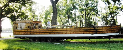
Our first camping experience (Monday - June 4) was at Lewis and Clark State Park just outside of Onawa, Iowa near the Missouri River. This very pretty campground with affable hosts gave us a chance to test out our gear in relatively tame circumstances. (A stop was made the next day in Sioux City, IA at a Wal-Mart to give the participants a chance to make some minor changes to their gear). At this campground we saw an exceptional sunset across the lake, checked out a full sized replica of the keelboat that Lewis and Clark used for their expedition, experienced voracious mosquitoes, bull frogs singing loudly all night, and the sound of the interstate on the other side of the lake. We also saw and photographed a bog which had many beaver lodges and red-winged blackbirds singing in the early morning light.
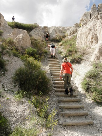
Our next nights camping, as well as our first hiking experience, was in the Cedar Pass Campground in the Badlands National Park in South Dakota. We claimed our campsite and decided to get in a couple of hikes while there was still good daylight. We did the short Window, Door and Notch Trails. The Notch Trail was the most exciting as it involved scrambling up a log ladder and after a mile and a half ended at a spectacular overview of the Badlands below. We decided to eat before returning and setting up our camp for the night. Some of us enjoyed the local restaurant specialty, an Indian taco made with fry bread and buffalo meat. Unfortunately it was getting dark when we got back to our campsite and a high wind had picked up making pitching our tents in the dark difficult. There was a huge full moon and a stiff wind all night flapping anything loose on tents which caused some to sleep poorly.
The next morning after breakfast in camp, we broke camp and hiked a portion of the 10 mile Castle Trail. We toured the Visitors Center and some watched a short filmstrip on the Badlands which described it as the "land of constant wind" while others purchased books. Next we attended the short ranger presentation on fossils and walked the short Fossil Trail. Lunch was in the well known tourist destination, Wall Drug Store, in Wall, South Dakota.
Then (Wednesday - June 6) it was on to the Black Hills of South Dakota where we camped at a National Forest Campground at Horse Thief Lake where the very accommodating hosts assigned us beautiful campsites overlooking the lake. These hosts also recommended driving the Pigtail Highway and gave us a map as a guide for our loop. This road is US 16A, the Iron Mountain Highway, and is called Pigtail because of the number of bridges where the road loops over itself. It also features three tunnels which frame Mt Rushmore in the distance and places where the two lanes separate from each other. One section of the road is along the edge of the Black Elk Wilderness (picture) where the famous Needles area attracts rock climbers from all over the world.
When we returned to camp, there had been a passing thunder shower which caused some grief for any who had left their rain flys open. We chose to go into town (Hill, SD) that evening and eat at ahole-in-the-wall diner that was something less than satisfactory rather than cook at the damp tables.
It rained again during the night, so the next morning we again drove to a restaurant at a nearby KOA for breakfast. We returned to the campground, and after making sure that all tents were closed down in case of rain, we started out up the Horsethief Lake Trail at the back of the campground for an eight mile (round trip) hike with 2240 elevation gain. At the intersection with South Dakotas Centennial Trail (a 111 mile long trail through the Black Hills National Forest) we took a left onto that trail and followed it through granite needles and poison ivy to the My Rushmore spur. From there we climbed to a beautiful view of Mt Rushmore from the left. All faces except Roosevelt are visible in profile from this vantage point.
(Picture) Here we had lunch before going on over into the Rushmore Memorial area. After picture taking opportunities there, we headed back down the trail to the campground as it looked like rain. After about an hour rain began, to be quickly followed by a hail storm that lasted the rest of the way. Most of the hail had a penny-size diameter with some quarter size. Several of us received bruises that were still visible 10 days later. The ground was soon covered with a blanket of hail half an inch to an inch and a half in depth. The rain was also heavy, with water flowing down the trail, and wet areas we crossed on the way up were full of rushing water. (picture) Our campsite was covered with a layer of hail, and puddles. We were soaked and cold. It was still raining lightly. We changed into dry and warm clothes, left our tents, and got rooms at a Comfort Inn in Hill City. Supper was at the Big Horn Restaurant followed by a visit to a laundromat.
The next morning after breakfast on the patio at the motel where the day had dawned crisp, bright and clear, we returned to our campsite to get our gear cleaned up and dried out. Owing to our late start, we decided to forgo our planned side trip to Devils Tower that morning and eat lunch in a small local restaurant found on the internet in Sundance, Wyoming. The lead car proceeded to Sundance as planned, but the second car upon seeing a similar car exit the interstate towards Devils Tower, followed that car off the interstate. When that car took off at close to 100 miles an hour, they tried to call on the cell phone but had no reception. Meanwhile those in the lead were sitting in the restaurant in Sundance trying to raise the others on the cell phone. The folks in the second car finally had service when they got in the vicinity of Devils Tower and were informed of their mistake. Meanwhile Betty and Linda had fun checking out the real-life cowboys having lunch in that little café.
That night we camped at Sitting Bull Campground in the Big Horn National Forest. (picture)
. Several of us felt a little dizzy and fatigued due to the 7,000' elevation. Mosquitoes were a problem for some. We saw a moose in the distance in the meadow behind our campsite.
The next morning, we arose and started up the Sitting Bull ATV Trail (#100) which ran out of the campground to East Tensleep Lake. But about halfway there we encountered a major crossing of Lake Creek that was too deep and swift for us to attempt. We turned around and went back to the campground, broke camp, and drove on to the West Tensleep Lake parking area at the end of a dirt Forest Service Road that I had been worried about driving. It proved to be in pretty decent shape, so it would have been better to have come there earlier to start our days hiking. As it was we were able to hike to the wilderness boundary on trail #65. We had lunch at a very pretty little valley (picture) and turned around at a very pretty little waterfall.
We drove on from there down the very picturesque Tensleep Canyon to Graybull where we turned west toward Cody. It was in the Tensleep Canyon that we encountered a huge bull moose in velvet that caused us to pull over to the side of the road for a picture taking moment.
We decided to spend the night (Saturday - June 9) in a motel in Cody since we would be camping the next six nights. We ate a rather hasty but good Mexican dinner before climbing on a shuttle bus to the Cody Stampede. Despite the fact that we all thought that we were warmly dressed, the wind in the grandstands cut through our clothes like a knife. However the show was worth it as that night they had bull riding and a competition for the bull fighters aka rodeo clowns.
Before leaving Cody the next morning, we visited the Sierra Trading Post when it opened, and then Walmart to upgrade our warmth factor a bit. We drove from Cody past the Buffalo Bill Reservoir to the East Entrance to Yellowstone National Park. We stopped to take pictures of the very beautiful Sylvan Lake just past the park entrance. On the way to the campground we passed Yellowstone Lake, bison in the distance, and thermal pools and vents. Arriving at Canyon Village Visitors Center, we were assigned three campsites that had been previously reserved for us.
Yellowstone Park is named for the Yellowstone River which cuts a canyon through sandstone that is quite yellow. In the afternoon we visited the Grand Canyon of the Yellowstone with stops at "Lower Falls," "Yellowstone River," "Inspiration Point," and the Visitor Center before having supper in the campground's restaurant. (Because of slow service we were given complementary desserts.)That night we became aware of how serious the park service is about food/bear safety rules when a ranger walked softly through our campsites in the middle of the night. People in the RV that was parked in the next campsite had left water out on their table and they were rudely awakened to get up and put it away appropriately.
We were up at 5:30 on Monday, June 11, and, after a camp breakfast, left for Dunraven Pass (8,859'). At 7:30 we began our three mile climb of Mount Washburn (10,243') by negotiating across a snowdrift at the trailhead. We were the first people on the trail, but were soon passed by two younger couples. There were great views virtually all of the way. The higher we went the more numerous and higher were the snowdrifts across the trail culminating with several 15 to 20 feet in height near the top. We tried to identify the various animal tracks in the snow, and saw marmots in the rocky areas. At one point a marmot approached Bill, who began softly talking to it, and it then licked his leg. His rapport with the marmots was noticed by other people on the trail. There is an old fire tower on the top of Mt Washburn which has a 360 view of almost the entire park including the Canyon of the Yellowstone, the Tetons and Old Faithful. There are signs explaining what features you are seeing in the distance. Lunch was inside the tower. By the time we descended the mountain, there were a great many more people climbing it.
That afternoon we drove through the Lamar Valley where we saw bison, antelope, and deer, at a distance, plus a coyote which crossed the road in front of us. Supper was in the campground restaurant, followed by showers and doing laundry. - - This was a great day!
On Tuesday, June 12, we were up at 5:30, broke camp, had breakfast in the campground restaurant and were on our way by 7:30. We stopped at the thermal "Artists' Paintpots" on the way to see Old Faithful. Our timing was great. Old Faithful was just beginning an eruption as we walked up. Afterward, we walked the 1.4-mile boardwalk and trail witnessing and photographing numerous other thermal vents, geysers, and mud pots. We returned and had lunch in the area restaurant before we continued on to the Grand Tetons.
Arriving at the Grand Teton National Park, Coutler Bay Village Campground, we were assigned RV campsite L233 since it was level and would accommodate our 6 tents. After setting up, and fixing supper, we visited the General Store and then had a campfire. Some of us discovered that there was a short trail out of one of the camping loops to the shore of Jackson Lake with a spectacular view of the Tetons at sunset. The night sky was beautiful, full of bright stars. The Big Dipper was overhead.
Wednesday morning, up at 6:15 and ate breakfast before leaving to climb about 2,150' on the Death Canyon Trail to the junction with the Static Peak Trail. There is a back country ranger station at this junction used for staging rescues from the back country in season. The trail first climbs up the side of Albright Mountain to a magnificent view of Phelps Lake and then descends toward Phelps Lake before splitting into two trails one circling the lake (Valley Trail) and the other (our route) climbing Death Canyon. Again a marmot approached Bill and licked his legs. We encountered some of the same people we had seen on Mt Washburn and learned that Bills reputation as the Marmot Whisperer was spreading beyond our little group. Near the top of our 8+miles hike we found snow and super beautiful, very full, rushing water cascades.
Back at the Moose Visitor Center Betty was informed by one of the rangers on duty that the planned hike for the next day, Granite Canyon Trail, was not possible because of snow. We would have taken the tram out of Teton Village Ski Resort to the top of the mountain and hiked down the Granite Canyon Trail back to the Village. That evening we ate at an outdoor barbeque nearby the Moose Visitor Center which was less than great. We returned to our camp and had a campfire.
Thursday morning we were up at 6:15, ate breakfast, and departed for the Jenny Lake area where we walked the 7.1 miles around the lake plus another 3-4 miles as we climbed the steep and rocky trail past Hidden Falls and up to Inspiration Point. We went back down the Cascade Canyon Trail at one point having to cross a snow pack. The first part of the trail from the Jenny Lake Visitor Center to String Lake was lovely in the early morning light with relatively few people. There were fishermen around the very pretty cascading stream between String Lake and Jenny Lake. The western side of Jenny Lake Trail was hot and exposed due to a past forest fire. When we got around to the ferry, it had just arrived disgorging large numbers of tourists looking to climb to Hidden Falls and Inspiration Point. In spite of the crowd, we managed to find a small corner off the trail near Hidden Falls to eat our lunch. We then climbed up to Inspiration Point discovering that there was another overlook part way up which fooled most ferry tourists into thinking that they had arrived at the point and turning back there so that the real Inspiration Point was not too crowded. By the time we had descended the rather rough portion of the Cascade Canyon Trail back to the Jenny Lake Trail repeating a portion of the Jenny Lake Trail on our way back to the Visitor Center we were getting quite tired. But the highlight wildlife encounter of our trip happened close to the end of this hike, a moose taking her time to cross the trail perhaps 75' in front of us, followed by her two calves.
We went back to camp to clean up a bit before dinner. Dinner, for some of us, was at the Jackson Lake restaurant where we had excellent local trout. Others cooked camp meals and watched the sun go down over Jackson Lake and the mountains near our campsite.
Friday we had breakfast and were on our way by 8 to hike the Garnet Canyon Trail. At the trailhead there was a sign indicating that a mother grizzly with two cubs were reported to be frequenting the area so caution was advised. This was a 9+ miles roundtrip hike with 2,400' elevation gain that ended with a large snow pack blocking the trail. We saw many blooming wildflowers and some elk in Lupine Meadow. Higher on the mountain we had views of Bradley and Taggart Lakes in the distance. We encountered an eleven year old girl hiking with her father whose goal was to climb as high on the mountain as she had been in a plane the day before. We also met some back country rangers who were carrying in supplies to a backcountry site further up the trail. As we ate lunch at the end (for us) of the trail, we were passed by a backpacking mountaineering group whose goal was climbing one of the peaks in the backcountry. The group again split for dinner that night but we ate at Coulter Bay. One group ate at the burger place, some cooked in camp and some ate at the fancy restaurant for another excellent meal of local trout.
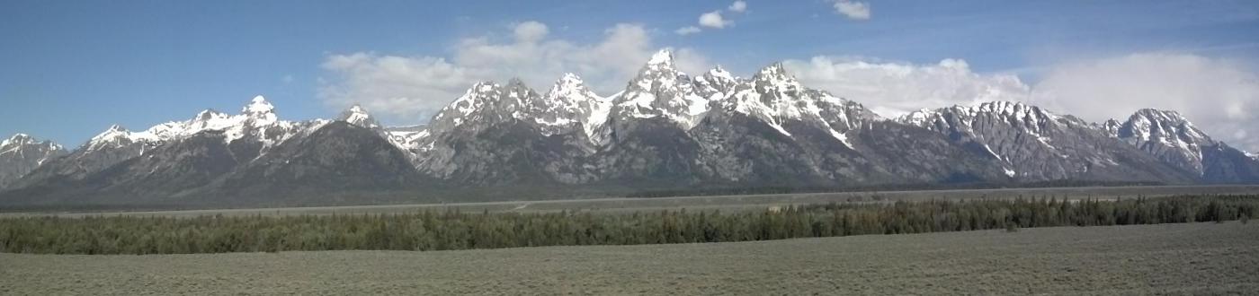
Saturday we broke camp and were on our way home by 8. We stopped at the same scenic point that we had stopped at our first day to take panoramic pictures of the Teton Range. Then we left the park through the southern entrance driving past the Wind River Range in the distance as we headed out into the prairie on the three day drive home.
Participants were Donald Box, Linda O'Neal, Janet Hale, Reggie Jay, Bill Kinnaman, and Betty Petty reporting.