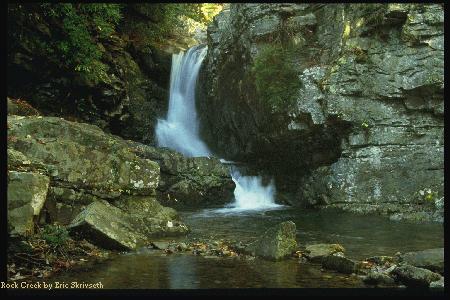
The Cherokee National Forest has two Rock Creeks, about 5 miles from each other. This trail goes to the Rock Creek Gorge Scenic Area where the waterfall pictured is located. There is a second waterfall upstream from the one pictured that is more spectacular but difficult to photograph. The Scenic Spur Trail is about a 3.4 mile roundtrip hike, easy, but has two stream crossings that can be quite deep on occasion. The trail head is on TN 30 about 100 yds north of US 64.
This little known trail is in the Little Frog Wilderness of the Cherokee National Forrest.
It starts, however, in a wellknown area. The trailhead is off an old paved road across Highway 64 from the Ocoee Whitewater Visitor's Center. The trail is 5.5 miles long
but ends at an intersection with the Benton MacKaye/Dry Pond Lead Trail about 2 miles from the nearest road, Highway 64. Therefore you must turn left onto the Dry Pond Lead Trail to make a total 7.5 miles hiked. There is a 2.7 mile car shuttle back
to where you started. The Benton MacKaye/Dry Pond Lead trailhead is directly across 64 from Ocoee Powerhouse # 3 and is well marked. This is a wilderness trail, and can be overgrown in places but is well-maintained these days because of the Benton MacKaye connection.
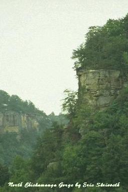
This trail was a part of the North Chickamauga Pocket Wilderness formerly owned by Bowater Corporation. It is now a part of the Cumberland Trail Sate Park trail system. It is known as the Stevenson Trail and is an extremely interesting and senic trail with many fine views and points of interest including abandoned coal mines. Like any area where there are cliffs and abandoned mines a certain amount of caution is necessary. North Chickamauga Creek flows through the Gorge and is very beautiful with a number of interesting waterfalls and cascades. The name "Chickamauga" means "dwelling Place of the Chief" in the Creek Indian language. This is an easy to moderate hike for a total of 8 miles. There are also opportunities for camping here. The parking area for the North Chickamauga Pocket Wilderness is off Montlake Road in Soddy Daisy.