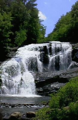
Bald River Falls is one of the best known and most frequently visited
spots in the Tellico/Citico area. It is near (not in) the edge of the Bald River
Gorge Wilderness, which at 3721 acres is actually a rather small area
as we think of wildernesses! [Editors Note: For this area to be
truly protected, the 10,460 acres of the Bald River watershed which
are now the Upper Bald Primitive Areas should be added to the
Wilderness.] Parking at the Falls is somewhat limited. About a
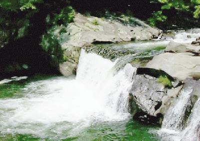
quarter mile up the road is a campsite beside a quite lovely falls (Baby Falls) on
the Tellico where additional parking may be possible.
The trail begins
in the parking area to the left of the Bald River Falls. The portion leading up
to the picnic area at the top of the Falls is paved and well constructed.
Once you leave the picnic area, however, great care must be taken to
stay on the true trail, (there is a switchback to the left) as there
are many fishing side trails which go to a point on the river and end.
Once you have gained access to the top of the ridge, the trail levels
out and follows the river to where it flows under FS126. Shortly
before this there is a small waterfall/large cascade where you may
enjoy lunch on the rocks. It is 4.8 miles to this point.
 Actually
there are many places along this very beautiful river where you could
enjoy lunch, if you wished to do a shorter hike. It is advisable to
plan an out-and-back hike as the drive to the other end of the trail
is over many miles of very rough road.
Actually
there are many places along this very beautiful river where you could
enjoy lunch, if you wished to do a shorter hike. It is advisable to
plan an out-and-back hike as the drive to the other end of the trail
is over many miles of very rough road.
To find this trail take whatever route suits you best to Tellico Plains.
The simplest (not the shortest) is to go north on I75 to SR68
(Sweetwater exit) and then go east to Tellico Plains. Follow the signs
for the Cherohala Skyway to the
junction with FS345, which has a sign pointing to Bald River Falls.
The Falls are to the right of the road and are hard to miss.[Editor's Note: Picture above is Baby Falls of the Tellico
where several drownings have occured due to a very strong undertow at the base of the falls.]
This trail is approximately 80 miles from Chattanooga.
To view a more technical description and maps, reference Cherokee Hiking Club Trail #88 PDF.