
Welcome!
Club Members get advance emails for hikes.
Not a member yet? Click here today!
Not a member yet? Click here today!
Interested in leading a hike? Want to know more?
Click here to connect with our Coordinator.
Chattanooga Hiking Club Outings
The Chattanooga Hiking Club, in keeping with its stated purpose, tries to provide outings every weekend for persons of different skill levels. Hikes scheduled in the current month and the upcoming month are described in detail. Tentative hikes are simply listed in the Outings Schedule and are still in the planning stages. All of our hikes are led by club members volunteering their time to the cause.
In addition to the weekend formal schedule, there are regular day hikes most every Wednesday closer to Chattanooga so that less driving is involved; and there are sometimes more spontaneous hiking road trips, usually on Thursdays and/or Fridays.
The information below is provided as a guide only. Each hiker assumes the risks associated with hiking in the great outdoors, including the responsibility for paying any bills associated with rescue efforts or medical care. The wise hiker always carries drinking water, food, and first aid items, and wears or carries clothing appropriate for the season. *Always check with the Hike Leader for special considerations like medical conditions and hiking with minors.
Hike Difficulty Rating
Easy(E): 6 miles or less; mostly level ground or only slight incline.
Moderate(M): Distance of 7 - 10 miles with an elevation gain that will generally not exceed 350 feet per mile, with a total elevation gain of no more than 1000 ft.
Moderately Strenuous(MS): This hike could be 7 - 10 miles in length, but include rocky trail conditions, tricky stream crossings or elevation gain of more than 1000 ft. but less than 2000 ft.
Strenuous(S): Any hike that is a distance of 10 to 14 miles or with more than 2000 ft. total elevation gain, but no more than 3000 ft.
Extremely Strenuous(S+): Usually involves distances of more than 14 miles or more than 3000 ft. in elevation gain. There might be very steep/rugged climbs, deep stream crossings, or unmaintained trails.
Pace: Standard pace (SP) is 2 miles per hour; less on steep or rugged terrain. Fast pace (FP) is 2.5 to 3 miles per hour or more and may not vary much regardless of terrain.
For more information and to view the Chattanooga Club Policies and Constitution please click here.
|
Hike Report!
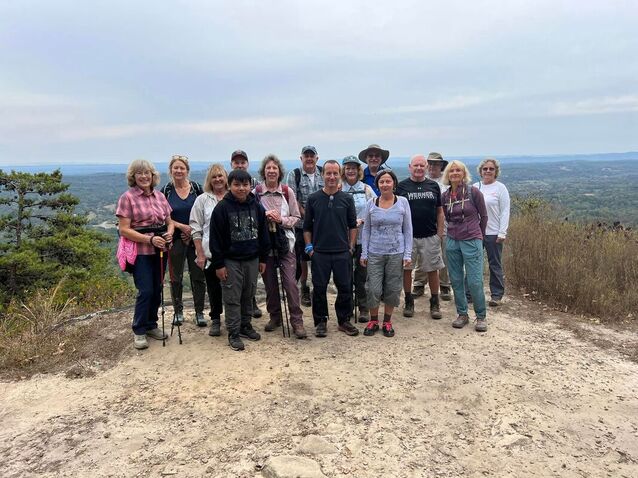
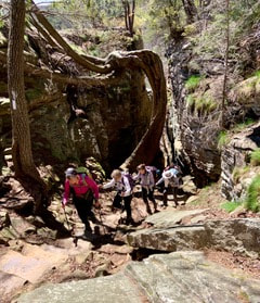
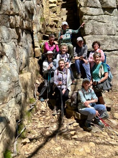
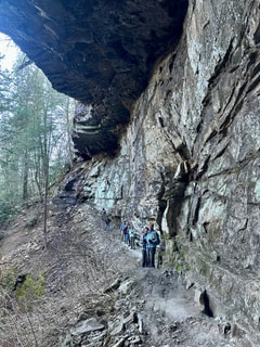
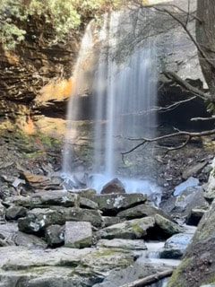
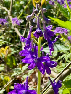
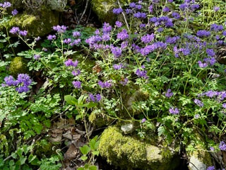
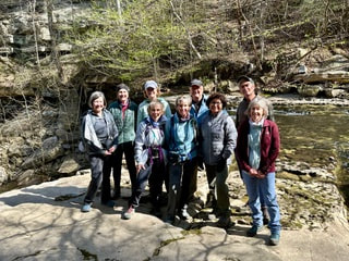
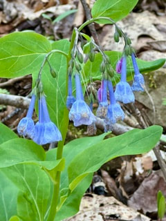
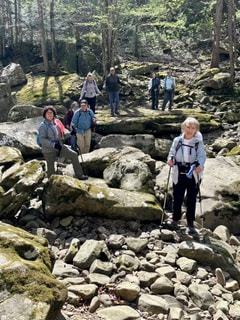
Saturday, April 6 Collins Gulf / Stone Door We were so fortunate to have a beautiful day for this wonderful springtime hike. The wildflowers surpassed our expectations with hillsides full of purple phacelia and white trillium. There were also quite a few of the very beautiful larkspur with a few celandine poppies and bluebells. We counted 30 species of wildflowers. We were able to enjoy waterfalls, but luckily, we didn’t have so much water that we had to take off boots for two unbridged crossings. Three suspension bridges, 1600 feet of climbing, walking through the Great Stone Door, views from the bluff, and a great group of hikers made for a wonderful 10 mile hike! Hikers included: Jenny Hopkins, Rita Pendergast, Steve Barnes, Helen Layne, Debbie Lambert, Trish Franklin, Joyce Campbell, Deb Young, Mark Rice, and hike leader, Susan Faidley |
|
Upcoming Outings ~ Register w/ Hike Leaders today!
Saturday April 13th
In and Out Hike
Location: CT Via Soddy Gulf Trailhead
Distance: 8 miles
Elevation Gain: 1200 ft
Rating: Moderate-Strenuous
Pace: Standard
We will begin hike @ 9:00 am. Hike in on road running along Soddy Creek on up to CT and head south on trail towards Mowbray Pike TH. We will cross a big swinging bridge and continue to another small bridge where we will break for lunch and then return. Should see plenty of wild flowers.
To Register, email rita.pendergast11@gmail.com
Sunday, April 21
Durham Trails on Lookout Mountain
Miles: approx. 8 miles
Elevation Gain: approximately 900'
Rating: moderately strenuous
This will be prime time to see several varieties of wildflowers!
Need $5 exact for parking, or a GA Parks annual pass.
Email Jenny Hopkins at jenhop60@gmail.com to register.
Durham Trails on Lookout Mountain
Miles: approx. 8 miles
Elevation Gain: approximately 900'
Rating: moderately strenuous
This will be prime time to see several varieties of wildflowers!
Need $5 exact for parking, or a GA Parks annual pass.
Email Jenny Hopkins at jenhop60@gmail.com to register.
Saturday, Apr 27th
North Chickamauga Gorge Trail
Cumb. Trail from Montlake Road with Upper Hogskin Branch Loop to Waterfall and Back
Location: Soddy-Daisy
Driving Time: 20 min from downtown
Distance: 6.5 miles
Rating: Moderate
Elevation Gain: 1000 Ft
Pace: Moderate - Approx. 2 mph
Hike Leader: Dan Garner
Trail Conditions: Minor Creek fords, 2 ladders, short sections with narrow footing. [For those who may have done this hike before, the State Park Service has upgraded the stones of the creek crossings, and improved much of the trail, making the crossings and some parts of the trail easier to hike.]
In my opinion, this hike has some of the most spectacular scenery of any hike in our immediate area. Parts of trail leads to some famous "Blue Hole" swimming spots, so hiker traffic can at times be heavier than usually seen on the CT.
From the Montlake Road Trailhead, we immediately ascend to an old mine road on the Upper Hogskin Loop, then a slow steady 1.2 mile climb to an old Mine Tippet Remnant, a small waterfall, and the open mouth of an old Coal Mine. Then there is 3/4 mile moderate difficulty traverse, just under the escarpment, coming to the ladders leading up to the spectacular Boston Branch Overlook. , We then walk one mile of easy hiking on a second old mine road to a second set of ladders, which we will descend to a level where there is a very pretty small unnamed Waterfall. here we'll take a lunch break and then return back to the trailhead. As there are a few small water crossings and some short stretches which narrow footing along the escarpment, use of TWO trekking poles is recommended.
Please register at garnerd6739@gmail.com or text 615-498-0560.
Saturday, May 11th
Rock Creek
Distance: 9-10 miles
Elevation Gain: 1100 ft
Rating: Moderate-Strenuous
Pace: Standard
Time: 8:30 am
Hike Leader: Kendrick Mills
Join us for a hike on the Rock Creek portion of the Cumberland trail. We'll enjoy varied terrain, an eagle's eye overlook into Boiling Springs Hollow, the nearly constant roar of Rock Creek below, and a lovely waterfall at Leggett Branch. We'll stop at the waterfall for a break before retracing some (but not all) of our route back. The footing is usually good with some wet spots after recent rains - but that just makes the creek louder and the waterfall better! There are some stream crossings, but the rock hops are reasonable.
We will be meeting at the Lower Leggett trailhead of the CT to begin. (don't go to the Upper Leggett TH).
Register at: LKMills@gmail.com or 615-944-5320
Saturday, May 18
Walden's Ridge Park, Signal Mountain
Distance: 4.5 - 5 miles
Elevation Gain: 700 Ft
Rating: Easy-Moderate
Pace: Moderate
Leader: Shelly Lewis
We'll hike one of Chattanooga's newest parks (opened Septmber 2023). This 4.5 to 5 mile roundtrip hike starts at a lower parking lot off Reads Lake Road and we will hike up to the W road and back on a shared hiking/biking loop. There is also a trail that leads to a small waterfall (when in season) that we'll take a peek at if flowing. This is a gently sloping wooded trail circling the park with many long switchbacks. As an FYI - all of the interior trails are steep and graded for downhill mountain bikes only. Trail head is only 10 minutes from downtown Chattanooga. Many of you may have been on the hike with the Wednesday group a month ago. The hike will take about two and a half hours.
Register by email or text: Lewisshellytn@yahoo.com or 925-683-6095
Sunday, June 23
Bear Creek Backcountry Trail @ Cloudland Canyon State Park
Miles: approx. 7.3
Elevation Gain: approx. 1,300'
Rating: moderately strenuous
Pace: standard
It's only 1 mile to hike down to Bear Creek, and probably the prettiest spot in the whole park. Depending on recent rainfall, we will either rock hop across or remove our shoes. Then we'll climb up the other side where we'll hike the loop portion, returning to Bear Creek for a second crossing before the final climb out.
Need $5 exact for parking, or an annual GA Parks pass.
Contact Jenny at jenhop60@gmail.com for meeting location and time.